Trail Valley Creek - Round 2
Day 7 Return to TVC. With the warm weather, even research aircraft need to be de-iced before they depart. This meant that we had to wait for an added 30-40 minutes for the crew from Inuvik (Mike Zubko) Airport (YEV) to come and de-ice the plane. In the meantime, another aircraft, a Cessna 208 was waiting to take off and a Twin Otter was parked next to the DC-3. Although it is a bit geeky, I hope that at some point we can get certified for the Twin Otter (not in the right of the photo below - according to our co-pilot, it is a Dornier 228). This would mean that we have our bases covered for more Arctic aircraft radar surveys.
From right to left: Cessna 208, our DC-3 Polar 5, and not a Twin Otter.
So after some pre-discussions we took off and headed back to TVC to fly the lidar, geodetic camera, snow radar and the CryoSAR. The day was great and we even had a bit of a tour of the Mackenzie River delta.
And then there were times when minor things did not go to plan. Like trying to figure out how to lower the jump seat in an aircraft.
Looking out over the delta
Close up of the ice road near Reindeer Station
Reindeer Station (bottom right).
The Mackenzie River delta is an amazing place in the winter time. Especially when viewed from the air. It is a real text book example of river geomorphic features that we all learned about in our high school classes - river meanders, oxbow cut-offs, oxbow lakes. Added to the fact that the terrain here, as in many places in Canada, is littered with water bodies. Once you climb out of the delta, (to the right), the tundra takes over and the lakes while there, are a little less concentrated.
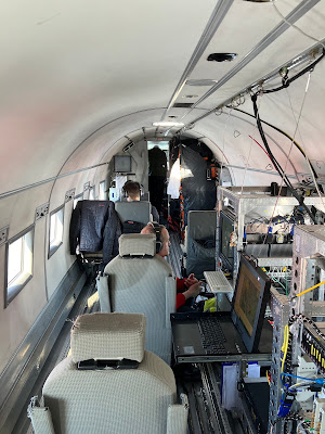
Back on board the aircraft, we seem to have settled into a fairly predictable routine for jobs. In the photo below, Christian (standing) is helping out with the snow radar with Jeff (seated at the rear) running the snow radar and MACS camera, while Martin (red coat) operates the lidar and keeps us all on track. Richard is at the front checking the SAR operation - at least that is what he says.
Working away
And for a change, here is the view from the back to he front of the aircraft. Martin is actively monitoring the lidar, Arttu is having a break with Christian managing the flight paths ahead of him. Richard could have fallen asleep although it is unlikely.
And then there were times when minor things did not go to plan. Like trying to figure out how to lower the jump seat in an aircraft.
Jump seat operation fail!
About 6 hours of flying can cover a lot of ground. In our case we were mowing the lawn, so to speak. The flight navigation GPS track is shown below on a map - if only these were my Strava tracks!!
The day was long but in the end we were glad to be back on the ground. Then dinner and bed in preparations for anoter long day then next day our over the sea ice.
Tomorrow; Beaufort Sea (sea ice and snow on sea ice)and acquisitions over a SmartICE field site on the ice.


.jpeg)


Comments
Post a Comment